Louga
Louga (لوجا; Wolof: Luga) is a town in northwestern Senegal. Louga is a cattle market centre, and has road and rail links with the port city of Saint-Louis to the northwest and Dakar to the southwest. The area surrounding Louga is at the northern limits of Senegal's peanut- (groundnut-) growing area and is inhabited by the Fulani, who are generally pastoral nomads, and the Wolof, who are sedentary farmers. Louga is located in what is called the Ndiambour, which used to be part of the Cayor province.
In 2013, according to official figures from the National Agency for Statistics and Demography (Senegal) (ANSD), Louga had a population of 104,000 inhabitants.
Louga is both the capital of the Louga department and of the Louga region.
The administrative region of Louga was formed in 1976, divided into 3 departments with 11 districts and 48 communities. There are 7 municipalities.
The Louga region is made up of 3 departments:
* Louga
* Kebemer
* Linguere
Map - Louga
Map


Country - Senegal
 |
 |
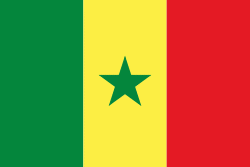
| Flag of Senegal | |
Senegal is notably the westernmost country in the mainland of the Old World, or Afro-Eurasia. It owes its name to the Senegal River, which borders it to the east and north. The climate is typically Sahelian, though there is a rainy season. Senegal covers a land area of almost 197000 km2 and has a population of around million. The state is a unitary presidential republic; since the country's foundation in 1960, it has been recognized as one of the most stable countries on the African continent.
Currency / Language
| ISO | Currency | Symbol | Significant figures |
|---|---|---|---|
| XOF | West African CFA franc | Fr | 0 |
| ISO | Language |
|---|---|
| FR | French language |
| WO | Wolof language |